Thursday, March 26, 2009

DDOT's Chief Engineer Penney on the 11th St. Brigde Project

The below article has been excerpted, in its entirety, from the February 2009 Hill Rag's "the last word", Pages 155 and 156.(Note: highlights, bold-text and [text] have been added)


The successful completion of the 11th Street Bridge Project has the potential to redirect 1,000s of commercial and commuter vehicles from the Greater Capitol Hill Neighborhood Street Grid (GCHNSG), including C Street, NE!

C Street, NE and subsequent residential streets carry nearly 20,000 west-bound vehicles, most out-of-district commercial and commuter motorists, each weekday. Constructing the new 11th Street Bridge, with the I-295/Kenilworth Ave. and I-395/East-west Freeway connection, is essential to redirecting regional-commuter and downtown-destined vehicles, currently using C Street, to appropriate and designated routes. The solution to redirect these vehicles is two-fold, first make it “more appealing” to use the existing freeways infrastructure by creating an uninterrupted connection between the two existing freeways, and second, making it “less appealing” to use the GCHRSG by placing strategic neighborhood scaled traffic-calming devices to make it difficult to traverse the GCHRSG from I-295/Kenilworth Ave to either downtown or I-395/East-west Freeway.

Without this important piece of the transportation puzzle, our community will continue to resort to using "bubble-gum fixes" in a feudal attempt to restrict and manage the overwhelming current traffic volumes flowing through the Greater Capitol Hill Community and never fully realize Capitol Hill's potential as a "livable, walkable community".

Also, WashCycle refers to the DC Chief Engineer's editorial in a recent post, HERE, discussing the proposed 11th Street Bridge project from a cyclist perspective.

For more on the project...

HERE is the February 2009 "Waterfront Watch" newsletter, published by the Anacostia Waterfront Civic Engagement Program, which includes reference to Kathleen Penney's Hill Rag article.

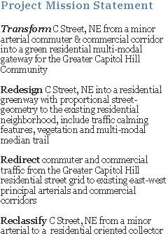
Below is a DDOT newsletter, from July 2008, providing general project goals and design objectives.


(click on image for a larger view)


(click on image for a larger view)


HERE is a link to DDOT/Anacostia Water Initiative’s 11th Street Bridge Project website

Greater, Greater Washington blog has a 3 part series discussion on the project, Part 1, Part 2 and Part 3.

Wednesday, March 25, 2009

Traffic Calming Measures in Mayor's 2010 Proposed Budget

Below are a few excerpts from a Washington Post article today, read the full article HERE, about some of Mayor Fenty's proposed revenue generating items to balance the 2010 budget. Some of these items are geared towards motorists who violate current city vehicular traffic laws. C Street, NE is a great place for some of the proposed items, if implemented; especially, over-weight trucks and motorists who accelerate through yellow signal-lights.


(click to view larger version, highlights have been added)


(click to view larger version, highlights have been added)

Tuesday, March 24, 2009

2008 & 2009 National Marathon Photos

Below are a few photos of the 2009 and 2008 National Marathon along the 1700 block of C Street, NE.

Once a year, C Street residents enjoy a peaceful weekend morning without roaring truck and car traffic. Instead, the faint, muffled pitter-patter of running shoes on worn-out asphalt. Bliss!


2009 National Marathon Sign


2009 - 1700 Block of C Street, NE - Looking West


2009 - 1800 Block of C Street, NE - Looking East


2008 - 1700 Block of C Street, NE - Looking West

Monday, March 16, 2009

Request to Revise C Street, NE 'Local Destination Sign'

A DC Service Request, see request below, has been submitted to revise the existing blue 'local destination sign', sign no. V10905, on the C Street, NE median just west of 17th Street. Note: currently this sign is directed towards motorist, not pedestrians or cyclists.


DC Service Request #2057886

The service request, submitted to DDOT, is to revise/update the 'local destinations' from "Downtown" (east sign face) to community based destinations, such as: "Eastern Market" and "Lincoln Park" (pointing toward North Carolina Ave) and "Stanton Park" (pointing straight on C Street). The service requested also recommends adding "Anacostia Riverwalk Trail" to the west sign face.


Existing East Sign Face (Arrow points towards North Carolina Ave and Lincoln Park)

The idea is to change C Street's image, and subsequent neighborhood streets, from a cut-through corridor to reach downtown, to a residential greenway connecting the Greater Capitol Hill community to it's great outdoor spaces.

Update: Allan Fye DDOT Transportation Planner, Transportation Policy and Planning Administration, spoke with DDOT's Lewis Booker, who manages the 'local destination sign' program (those architectural blue information signs), about the above request and Mr. Lewis stated he is personally working with the contractor to get the sign updated. Mr. Lewis is currently working with the sign contractor to update the downtown pedestrian directed blue local destination signs and then will begin updating the motorist directed signs.

Wednesday, March 11, 2009

WashCycle Discusses the Multi-modal Trail Designs


The WashCycle blog has discussed HERE and HERE the C Street, NE Project's conceptual raised-median trail and DDOT's suggested bike-lane configuration from the perspective of bicyclists.

Though the C Street, NE Project's "multi-model trail" would be geared towards, cyclists, roller-bladers, joggers/runners and walkers, the perspective of safety and mobility (uninterrupted travelling speeds) are worth consideration. The goal of the multi-modal trail, in essence, would be to extend the recently completed portion of Anacostia Riverwalk Trail (ART), which has a terminal at C & 21st Streets, NE., into the Capitol Hill community. This allows users a safer connection between their neighborhood and outdoor recreation spaces, such as ART, Kingman and Heritage Islands, Lincoln Park and Stanton Parks, Eastern Market, Langston Golf Course; and maybe someday, other destinations like the Aquatic Gardens and the Arboretum.


DDOT's Interim Anacostia Riverwalk Trail (ART) Map

Below are two excerpted images from NYC Department of Transportation Traffic Management Division, 2009 Boulevard Pilot Project, for Allen & Pike Streets referenced in WashCycle's post.


Interim Test Treatment
The above interim test treatment provides a living “vision” of what could be by testing the feasibility of closing certain cross street intersections, creating uninterrupted connections between the existing "Malls" (median segments) and using limited investment capital.


Long Term Conceptual Design
The above "Long-term Vision" of the existing median, "Malls doubled in width creating grand, Parisian-style linear greenway and community space".

Though the above median concept design is for a high-density, commercial and residential boulevard, the intent is the same, safely connect the community to it's outdoor spaces, provide open green spaces and reduce vehicular impact on the community. Image C Street, NE with a similar role for the community, it really isn't that hard.

Part of C Street, NE Project's conceptual raised-median trail design is to reduce one intersection, 18th Street (refer HERE), and employ "all-stop" intersections at the remaining vehicular crossing intersections (21st, 19th, 17th, 15th and 14th/Constitution Ave) to allow pedestrians to move in, out and along the trail. The traffic-signals could be sequences to assist in maintaining cyclist "flow" while travelling along the trail.

Thanks to WashCycle for picking-up and discussing the trail/path and David C. for the tips.