Policy T-2.5.4: Traffic Management
Establish traffic management strategies that separate local traffic from commuter or through-traffic and reduce the intrusion of trucks, commuter traffic, and “cut-through” traffic on residential streets. 411.14
Policy CH-1.1.13: Traffic Management Strategies
Establish traffic management strategies to reduce commuter traffic on East Capitol Street, Independence Avenue, C Street NE, 17th Street SE, and other predominantly residential streets that also function as throughstreets. These strategies should include limiting additional one-way streets on Capitol Hill (and possibly restoring existing one-way streets to twoway traffic), improving signal timing on Benning Road and Pennsylvania Avenue, and improving pedestrian and bicycle safety. Measures should also be implemented to route through-traffic around residential neighborhoods, and to restrict trucks and heavy vehicles on local streets. 1508.14
This is a follow-up post to a
great discussion (thanks to everyone who posted a comment) a few weeks ago relating to how best to manage and convey the majority of existing non-district commuter motorists cutting through the Capitol Hill community. From the comments, it appears there are two differing philosophies - use existing principle arterials and freeways or use the neighborhood street grid.
So, I asked resident mobility and transportation expert, Richard Layman of
Rebuilding Place in Urban Space, for guidance on the issue. He directed me to multiple resources, but I found the
2006 Comprehensive Plan from DC's Office of Planning most valuable to continue the discussion.
BTW, Richard is a "Jedi Master" in the field of urban revitalization and local/regional mobility and his blog is a vast resource which reflects his passion. So, thank you Richard for the guidance!
Below are a few select excerpted sections from DC Office of Planning's 2006 Comprehensive Plan relating to strategies for existing and future transportation/mobility demands. The Plan has two volumes, Volume I - Acknowledgements, Introductions and Citywide Elements and Volume II - Area Elements. In
Volume I, Chapter 4 discusses the Citywide Transportation Element and in
Volume II, Chapter 15 is all about the Capitol Hill neighborhood and includes specific transportation elements unique to our community.
Note: The 2006 Comprehensive Plan is now under the amendment process and the
2009 revised plan is due out in early 2010Chapter 4 – Transportation Element
Transportation Goal 401The overarching goal for transportation in the District is: Create a safe, sustainable, efficient multi-modal transportation system that meets the access and mobility needs of District residents, the regional workforce, and visitors; supports local and regional economic prosperity; and enhances the quality of life for District residents. 401.1
T-2.5 Roadway System and Auto Movement 411Traffic congestion on the District’s roadway network occurs primarily on the radial principal arterial roadways. Figure 4.3 [I believe it is actually "Figure 4.4" below] illustrates traffic volumes on major streets and highways. The flow of traffic is greatly influenced by north-south movements along the I-95 corridor feeding into I-295 and I-395. These highways carry the heaviest daily traffic volumes in the District with an average of approximately 193,000 daily trips on I-395 and 80,000 on I-295. In addition, the limited number of crossings over the Potomac and Anacostia rivers generates higher volumes of traffic at these gateways than their counterparts in the northern portion of the District. 411.6

As part of the Comprehensive Plan revision, an analysis of the transportation impacts of anticipated 20-year land use and transportation changes was conducted. The analysis projected a 20 to 25 percent increase in the total number of transit trips by 2025, and about an 11 percent increase in the total number of vehicle trips. Much of the increase is associated with off-peak travel and a “spreading” of the commute period over additional hours of the day. Vehicle congestion will increase on several corridors. The analysis concluded that new transportation demand management measures and transit improvements will be needed, both in the city and in the region, to keep the system functioning adequately. 411.10
Policy T-2.5.1: Creating Multi-Modal CorridorsTransform key District arterials into multi-modal corridors that incorporate and balance a variety of mode choices including bus or streetcar, bicycle, pedestrian and auto. 411.11
Policy T-2.5.2: Managing Roadway CapacityManage the capacity of principal arterials within existing limits rather than increasing roadway capacity to meet induced demand for travel by car (See text box on page 32). Increase auto capacity on roadways only if needed to improve the safety of all travelers, improve connectivity of the multimodal transportation network, or improve targeted connections to regional roadways. 411.12
Policy T-2.5.4: Traffic ManagementEstablish traffic management strategies that separate local traffic from commuter or through-traffic and reduce the intrusion of trucks, commuter traffic, and “cut-through” traffic on residential streets. 411.14
Action T-2.5.B: Signal Timing AdjustmentsRegularly evaluate the need for adjustments to traffic signal timing to minimize unnecessary automobile idling. 411.16
Volume II - Area Elements
Chapter 15 - Capitol Hill Area Element
The Capitol Hill area has an excellent transportation network, making auto ownership an option rather than a necessity for many households. The scale and topography of the neighborhood, as well as wide sidewalks and street trees, create ideal conditions for walking. The southeast portion of the Hill is served by the Capitol South, Eastern Market, Potomac Avenue, and Stadium- Armory Metro stations. Arterials like Pennsylvania Avenue and East Capitol Street provide excellent east-west circulation. The downside, however, is that Capitol Hill neighborhoods suffer from heavy volumes of commuter traffic going to and from areas east of the Anacostia River. The community is also easily accessed by I-295 and the Southeast/Southwest Freeway (I-695). 1500.6
Planning and Development Priorities 1507Several Comprehensive Plan workshops took place in the Capitol Hill Planning Area during 2005 and 2006. These meetings provided an opportunity for residents to discuss both citywide and neighborhood planning issues. There were also well-attended briefings to the Capitol Hill Restoration Society, the Capitol Hill Association of Merchants and Professionals, and the local Advisory Neighborhood Commissions. In addition, recent Small Area Plans—including the H Street Planning program and the Reservation 13 planning process—involved many Hill residents and addressed long-range planning issues such as land use, traffic, housing needs, and public facilities. 1507.1
The community delivered several key messages during these meetings. These are summarized below. 1507.2
k. A s already noted, Capitol Hill is intersected by major commuter routes serving the Maryland suburbs and areas east of the Anacostia River. Its neighborhoods are also vulnerable to overflow traffic when the freeways are congested. Residential north-south streets are often clogged with “cut-through” traffic as commuters weave between the east-west arterials. This creates noise, air pollution, and safety issues for residents. One-way streets have been established to facilitate traffic flow but the streets are not always paired, leading to circuitous travel and high volumes of fast-moving commuter traffic. Street and lane closures, illegal parking, and poorly timed signals contribute to congestion problems. At one time, a freeway link was proposed between I-295 and I-395 via Barney Circle, but this project was cancelled in the 1990s. A more recent proposal calls for removal of a portion of the Southeast/Southwest Freeway, its replacement with an at-grade roadway between Barney Circle and 8th Street, and a tunnel in lieu of the elevated freeway between 8th Street and South Capitol Street. While this would remove a barrier between Capitol Hill and the waterfront, there are many questions yet to be answered about the effects on traffic and adjacent land uses.
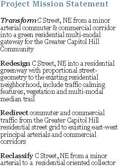
Policy CH-1.1.13: Traffic Management StrategiesEstablish traffic management strategies to reduce commuter traffic on East Capitol Street, Independence Avenue, C Street NE, 17th Street SE, and other predominantly residential streets that also function as throughstreets. These strategies should include limiting additional one-way streets on Capitol Hill (and possibly restoring existing one-way streets to twoway traffic), improving signal timing on Benning Road and Pennsylvania Avenue, and improving pedestrian and bicycle safety. Measures should also be implemented to route through-traffic around residential neighborhoods, and to restrict trucks and heavy vehicles on local streets. 1508.14
Policy CH-1.1.14: Southeast/Southwest FreewayMitigate the effects of the Southeast/Southwest Freeway; including noise, emissions, dust, and visual blight on adjacent Capitol Hill neighborhoods. Continue to evaluate the transportation and land use impacts associated with the freeway’s proposed replacement with an at-grade boulevard and tunnel. 1508.15
So, in my opinion, DC Office of Planning, DC Department of Transportation and the Capitol Hill Community have already identified existing transportation problem conditions and outlined community and city-wide level solutions for the betterment of Hill residents (quality of life and safety) and enhance commuter and visitor travel efficiency. Now, it's time to ensure these 'policies' and 'actions' are reviewed and implemented into all current and future transportation projects that impact the Capitol Hill community.
What are your thoughts and opinions on DCOP's 2006 Comprehensive Plan vision regarding existing and future transportation and transit issues in and around the Capitol Hill community?
Ken Granata