Join Us!
What: C Street, NE site visit with DDOT Transportation Planner Mr. Allan Fye
When: January 5, 2009 @ 7:30AM
Where: Northeast Corner of C Street and 17th Place, NE
Why: To view and discuss morning rush-hours traffic conditions with DDOT
Mr. Allen Fye, DDOT Transportation Planner, recently filled, what was, the Ward 6 Transportation Planner position formerly held by Mr. Chris Delfs (it appears DDOT Transportation Policy and Planning Administration has restructed the planning department from wards to regions). He proactive contacted us requesting to familiarize himself with the C Street, NE current conditions and the proposed objectives.
Hope to see you there!
Ken Granata
Wednesday, December 31, 2008
Welcome to the C Street, NE Project Blog!
Welcome to the C Street, NE Project Blog!
This blog was created to collectively gather citizen, civic-representative and civil-servant support to transform C street, NE, from 21st Street to 16th Street, from a minor arterial commuter & commercial corridor into a green, residential gateway for the Greater Capitol Hill community.
C Street, NE Project Manifesto
1. Provide a central location to disseminate and access timely C Street, NE related information and resources
2. Create a community forum to discuss current C Street, NE problems and consider future solutions
3. Build and maintain support and momentum for permanent, positive changes for C Street, NE during the next scheduled reconstruction project
Thank you for visiting the site,
Ken Granata
PS… one suggestion, use the "Blog Archive" bar on the lower right portion of the site to readily access relevant information. Because there is so much supporting information and the limitation of this blog structure, a variety of existing and proposed data has been organized as individual posts, refer to the below example:

Tuesday, December 30, 2008
Interim Remediation - Remove 1 West-bound C Street Vehicular Lane
We are currently lobbying DDOT to remove one west-bound C Street, NE immediately after the Benning Road Reconstruction Project is complete (secheduled completion date is currently 12/09). CM Tommy Wells has agreed to this proposal and has sent a support letter, at the request of the RCA Transportation Committee, to DDOT Interim Director Frank Seales on December 22, 2008. A copy has been sent to RCA and will be posted once it is received.

Existing Condition

Proposed Condition

Existing Condition

Proposed Condition
Monday, December 29, 2008
NCPC - RFK Stadium Site Study Vision for C Street, NE

Obviously, NCPC - RFK Stadium Site redevelopment Study is just that, a study. And, all concepts, layouts and visions for the large parcel are only conceptual to foster discussion of the site's potential as major destination for both residents and tourists.
But, I have to agree with the Study, Constitution Ave and Independence Ave (flanking East Capitol Street) should be reconstructed as the axial corridor connecting the monumental core to Capitol Hill East's Anacostia River shores. This moves the original DC layout much closer to its envisioned symmetry. Refer to the excerpted text below...

What is most exciting in NCPC's conceptual "Street Network", proposing C Street terminate at the edge of the site's green-space area and disconnect completely from East Capitol Street, as currently configured. Whether this vision is ever realized or not, directing downtown destined (or inversed, leaving downtown) vehicular traffic to use current major east-west commercial arterials (such as, Pennsylvania Ave, New York Ave and Benning RD/H Street) is vital to the health and safety of all Capitol Hill residents and visitors.
Tuesday, December 23, 2008
DDOT Planned C Street Construction Project on "Paper" Only

Extracted from DDOT's "Ward 6 Planned Construction Projects" website
Here is a potential opportunity to 'spring-board' the envisioned C Street, NE project into reality. From the beginning, we have urged DDOT Transportation Policy and Planning Administration to consider redesigning and constructing C Street during the next scheduled "pavement resurface/restoration" construction project. When that is actually schedule to take place is to be scene, though we have asked DDOT, but have not received an answer yet.


Existing and Proposed - C and 21st Street Intersection

Existing Condition (this photo was extracted from Google Earth. It is does not depict the current interesction configuration. The northeast corner noew has a pedestrian bulb-out. It was constructed in 2007 as part of access upgrades for either RFK Stadium or the Anacostia River Trail)

Proposed Design
Wednesday, December 10, 2008
C Street, NE - Proposed Design & Layout Objectives
Redesign, Redirect & Reclassify
Creating a Green, Residential, Multi-modal Gateway for the Greater Capitol Hill Community
Decrease -
1. Out-of-District Commuter & Commercial Vehicular Traffic Volumes
2. Vehicle Excessive Speeding
3. Vehicular Noise Pollution
4. Vehicular Airborne Particulate Pollution
5. Heat-island Effects
6. Storm-water Runoff
7. Roadway Maintenance Costs
Increase -
1. Residents’ Quality-of-Life
2. Pedestrian, Student & Cyclist Safety
3. Pedestrian/Cyclist-friendly Connections between Rosedale, Kingman Park, Capitol Hill, the Anacostia River, Lincoln & Stanton Parks and Stadium/Armory Metrorail Station
5. Streetscape Vegetation & Tree Canopy
6. Greater Capitol Hill's "Green Community" Resources & Connectivity
7. Greater Capitol Hill's "Livable, Walkable" Regional Image
Tuesday, December 09, 2008
C Street, NE - Capitol Hill Transportation Study Existing Conditions

Here is a link to DDOT's Capitol Hill Transportation Study (CHTS) Website
SECTION TWO: POTENTIAL TRANSPORTATION PROBLEMS
2.2 Major Transportation Corridors
2.3 Common Problems Throughout the Study Area

SECTION ONE: GENERAL TRANSPORTATION CHARACTERISTICS
1.2 Characteristics of Roadways and Intersections
2006 AM Peak Period Origin Survey Results - Figure 14 from "Section 1.2 - Characteristics of Roadways and Intersections" (Excerpted Area)


This map and excerpted text indicate over 80% of the west-bound daily vehicles are out-of-District
2005 Existing Travel Speeds for AM Peak Period Map from "Section 1.2 - Characteristics of Roadways and Intersections" (Excerpted Area)

2005 Existing Travel Speeds for PM Peak Period Map from "Section 1.2 - Characteristics of Roadways and Intersections" (Excerpted Area)

2005 Existing Truck & Bus Restrictions Study Area Map - Figure 24 from "Section 1.5 - Bus and Truck Restrictions" (Excerpted Area)

C Street, NE currently has no weight restrictions for commercial trucks or buses, even though it is a residential street and bounds a school-zone to the south (Eliot-Hines JHS)
Recommendations from "Section 1.5 - Bus and Truck Restrictions" (Excerpted Text)

CHTS points out the "District of Columbia Motor Carrier Management and Threat Assessment Study" recommendations to create and identify specific truck routes to moves commercial vehicles in and out of downtown, refer to the above routes.
Transportation Hot Spot Recommendations for Northeast of Lincoln Park


Capitol Hill Transportation Study Northeast of Lincoln Park
C Street, NE - Existing Zoning

1999 DCOZ Existing Zoning Map
(Excerpted Area)
No Commercial Zoning along C Street, NE (between 21 & 16th Streets)
The Big Picture: Greater Capitol Hill Impact

The Big Picture: Greater Capitol Hill Map
C Street, from 21st to 16th Street Highlighted
C Street, NE Dumps 1,000s of Daily Commuter and Commercial Vehicles into the Greater Capitol Hill Neighborhood Street Grid (GCHSG)

West-bound Traffic Impact to Greater Capitol Hill Community
C Street, NE Dumps 1,000s of Daily Commuter & Commercial Vehicles Directly into Multiple School Zones and Neighborhood Parks
C Street, NE - Existing Functional Classification

DDOT 2006 Functional Classification Map (Excerpted Area)
C Street’s current Functional Classification encourages commuters and commercial vehicles to use the Greater Capitol Hill Neighbor Street Grid (GCHNSG) to move in and out of downtown
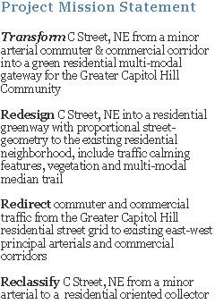
C Street, NE Project Mission Statement
Transform C Street, NE from a minor arterial commuter & commercial corridor into a green residential multi-modal gateway for the Greater Capitol Hill Community
Redesign – create a residential greenway with proportional street-geometry to the existing residential neighborhood, include traffic calming features, vegetation and multi-modal median trail
Redirect - direct commuter and commercial traffic from the Greater Capitol Hill Residential Street Grid (GCHRSG)to existing east-west principal arterial commercial corridors
Reclassify – classify C Street, NE as a residential oriented collector. Currently classified as a minor arterial
Friday, December 05, 2008
C Street, NE - Existing Traffic Volumes
DDOT 2006 Traffic Volume Map (Excerpted Area)


DDOT 2006 Traffic Volume Map Legend
As the above DDOT map indicates above, C Street, NE three west-bound vehicular lanes carry upwards of 20,000+ commuter & commercial vehicles each weekday
Graph & Table
DDOT 1-Day Traffic Volume Report
C Street, NE - Three West-bound Traffic Lanes
July 16, 2008


At the request of RCA Transportation Committee, DDOT conducted a 1-day Traffic Volume Study on C Street's three west-bound traffic lanes on July 16, 2008. Nearly 18,000 vehicles were counted for the 24-hour study period and about half of those west-bound vehicles were counted between 6AM - 9AM.
As of October 2008, DDOT's Transportation Policy & Planning Administration has placed funds in the FY 2009 local ROW spending plan for a focused traffic analysis of C Street, NE to specifically determine the impacts of reducing traffic capacity and altering the operational cross section on C Street, NE.
C Street, NE - Existing Conditions & Overview
C Street, NE Overview - Between 21st to 16th Streets

Currently, C Street looks, feels, smells and even tastes like a high-speed freeway – in-turn, motorist use it as an expressway
C Street, NE Existing General Street Geometry

C Street Statistics
Classified as Minor Arterial
Commercial Vehicles Permitted (no weight restrictions)
17,000+ Daily West-Bound Commuter & Commercial Vehicles travel between 21st & 16th Streets (DDOT July 16, 2008 1-day Volume Study)
80+% of Daily West-bound Motorist are Out-of-State Commuter & Commercial Vehicles (2006 DDOT's Capitol Hill Trasportation Study (CHTS))
MPD Special Operations Division (SOD) Mobile Speed Camera Unit Statistic (to be inserted)
Bounds Eliot-Hines JHS to the North – Within a “School Zone”
Completely Residential - No Commercial Zoning
C Street, NE - Existing Vehicle Speeds
DDOT/TSA Speed Study Map, April 2007 (Excerpted Area)

C Street's 85th Percentile Vehicular Speed is >38MPH – Posted Speed Limit is 25MPH. The DDOT/TSA map above was created from the data table below.
DDOT "D.C. Speed Study" August 2006, Prepared by Brudis & Associates, Inc. (BAI) Excerpted Summary Speed Table, Page 1 of 8

2006 Capitol Hill Transporation Study Map, AM Traffic Speeds (Excerpted Area)

As the DDOT map indicates, morning vehicular speeds exceed the post speed-limit along a majority of the C Street focus area. Additionally, the exceeded posted-speed-limit area (> 25mph) is directly within the Eliot-Hines JHS "school-zone", creating unsafe conditions for students traveling to school.
2006 Capitol Hill Transportation Study Map, PM Traffic Speeds (Excerpted Area)

Subscribe to:
Posts (Atom)