When: February 20, 2010 @ 10AM
Where: Maury ES, 1250 Constitution Ave, NE (gymnasium, doors on 13th St.)
What: The second workshop in a series of 4 scheduled meetings (two stakeholder workshops and two public meetings).
Bill Schultheiss, Project Manager, Toole Design Group, will present 4 conceptual designs. The workshop group will discuss and vote on a preferred conceptual design based on pedestrian/student/cyclist safety, environmental benefits, improvement to residents' quality of life, community connectivity and potential traffic impact. Bill will also review the next steps for the project.
HERE is a list of participants' suggested items from the 1st workshop.
Contact: Bill Schultheiss, Project Manager, Toole Design Group - wschultheiss@tooledesign.com
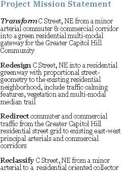
Project Overview: DDOT has begun a transportation and environmental study of the C Street and North Carolina Avenue corridor from 21st St. to 14th St., NE. The study is a result of community requests for safety and environmental improvements to the C St NE corridor. Results and recommendations from the study will be used to develop a preliminary design for the District’s first sustainable green street to efficiently and safely move people via foot, bicycle, transit and motor-vehicle. It is DDOT’s goal that this project be a community driven study that strives to attain an integrated infrastructure balancing the functions of mobility, safety, community connectivity, urban design and environmental sustainability.
The project will define means to improve safety for residents and school children, reduce storm water runoff and reduce traffic speeds. The findings and recommendations of the study will be reported back to the community for review and comment.
Thursday, February 18, 2010

Wednesday, February 03, 2010
THIH Covers the 01.12.10 C Street NE Public Meeting
Sharee Lawler, with the The Hill is Home, has covered the ongoing C Street, NE project and has written another great post about the January 12, 2010 C Street NE Project public meeting (1st of 2 scheduled meetings). You can read the post here.
As always, thanks Sharee and The Hill is Home for the continued support!
As always, thanks Sharee and The Hill is Home for the continued support!
Monday, February 01, 2010
RCA's C Street NE Mobility & Streetscape Design Suggestions
The following are mobility and streetscape design suggestions based on discussions with participants at the January 2, 2010 C Street, NE Workshop
Assembled by Rosedale Citizens' Alliance (RCA) Transportation Committee Members - Ken Granata & Rob Stephens
MOBILITY
1. C & 21st Streets Intersection – connection between bike lanes/sidewalk and the existing Anacostia Riverwalk Trail (ART) Portal (northeast corner of intersection)
• Signage - informing about ART, Kingman & Heritage Islands Park and future Environmental Center
• Vegetation
2. Reduce at least one west-bound vehicular lane and one east-bound vehicular lane along C Street and North Carolina Ave from 21st to 14th Streets
3. Reduce width of remaining east- and west-bound vehicular lanes along C Street and North Carolina Ave from 21st to 14th Streets to the minimum required lane width as mandated by DDOT
4. Provide bulb-outs at all C Street and North Carolina Ave intersection where pedestrian cross-walks are located
• Provides shorter pedestrian crossing
• Allows pedestrians and motorists to better see each other
• Creates roadway “choker” points
• Provide vegetation areas within the bulb-outs, as configuration allows
5. Provide raised crosswalks at major intersections
• 21st St
• 19th St
• 17th St
• 15th St
• 14th St/Constitution Ave
• 17th Place (see item 7 below)
6. Consider removing 18th Street intersection and signal to reduce spill-over traffic onto and through 18th Street and improve C Street traffic flow
• Create a median-barrier similar to existing cross-street barriers (20th St, 18th Pl, 17th Pl, 16th St and 14th Pl)
• Considering 17th St and 19th St will be reconverted to two-way streets, 18th Street residents will experience minimal access reduction
• No cross-street to the south only Eliot-Hines access ramp
• 18th Street extends only two blocks to the north
7. C Street & 17th Place - consider adding a new raised pedestrian crosswalk with cross-walk light
• 17th Place is a major de-facto point where many students transit to/from Eliot-Hine JHS.
8. Keep some type of median barrier for all or most of C Street and North Carolina.
• Determine what is the minimum size/width of a median for grass, shrubs and/or trees (i.e. vegetation) to thrive using two scenarios – a) natural - self-sustaining vegetation (only from rainfall and storm-water runoff) and b) artificial – supplemental watering from city, residents and/or others
9. Remove sweeping west-bound turning lane at North Carolina Ave and Constitution Ave
• Relocate and reconfigure exiting island to the curb-line
• Create sharper angled turn to slow vehicular movement
10. Remove C Street turning lane at 16th Street (turning movement onto 16th Street)
• Create green space
• Relocate, but keep, residential parking in front of C Street residences
• Decrease pedestrian crossing distance
11. Remove portion of C Street turning lane (turning movement onto 15th Street) between 16th and 15th Street
• Create green space
• Incorporate into bulb-out at 16th Street (west side) to reduce pedestrian crossing distance
12. Consider removing the west-bound turning lane at C Street on to 21st Street
• Minimize potential spill over onto 21st Street and the north side of neighborhood
13. C Street and North Carolina Ave west-bound split (mid-block between 17th & 16th Sts) – provide only one west-bound vehicular lane
• Increase island green space
• Reduce one west-bound C Street vehicular lane
• Decrease pedestrian crossing distance
14. Create physically separated bike-lanes (cycle tracks) along C Street and North Carolina Ave bike-lanes from 21st Street to14th Street.
• Located between curb-side tree boxes and vehicle parking
• Separated from vehicle parking by a minimal (2’-3’) width median with porous pavers (cobbles, bricks, etc.)
15. Prohibit commercial trucks and motor-coaches, greater than 1-1/4 tons GVW
• Based on the DDOT’s August 2004 Motor Carrier Management and Threat Assessment Study (http://ddot.dc.gov/ddot/cwp/view,a,1249,q,609850.asp)
STREETSCAPE
1. Any right of way width captured by the removal of vehicular lanes should be used to create additional green-spaces (natural ground surfaces to support vegetation).
• Most of the additional green space should be used to increase the width curb side tree –boxes instead of a wider median.
• Adding green-space (enlarging tree-boxes) will increase distance between residences and vehicular traffic.
• Residents are more likely to water and maintain green-spaces adjacent to their homes than the median.
• This does not preclude having green “islands” or wider green medians in certain sections where it is required or needed as a traffic calming feature.
2. When presenting options regarding street profiles/cross-sections that include areas with vegetation, present only options that are realistic and sustainable given the area size/width, type of vegetation and watering. Include features that will make it easy for residents to voluntarily water and/or maintain green areas adjacent to their homes. Be explicit and realistic regarding who is expected to provide water and maintenance (i.e. nature, city, residents or others).
3. C & 21st Streets Intersection – gateway elements to alert motorist that they are entering a neighborhood.
• “Welcome to…” sign
• Prominent median with vegetation
• Consider designating median space for future art work (sculpture)
• Consider textural/visual intersection roadway surface
• Consider raised intersection including crosswalks
4. Provide pedestrian oriented lighting
• Low light pollution
• Energy efficient
• Architecturally appealing
5. Provide roadway lighting that complements the neighborhood
• Low light pollution
• Energy efficient
• Architecturally appealing
6. Provide brick sidewalks
• Consistent with the Capitol Hill neighborhood
• Concrete base
7. Provide granite curbing
• Consistent with the Capitol Hill neighborhood
8. Provide porous hard surfaces- sidewalks, roadways and, if possible, bike lanes.
• Bike lanes surfaces should provide a smooth, safe and enjoyable ride.
9. Streetscape elements (not necessarily profile) such as materials (textures, colors), signage, lighting, vegetation, etc. should be consistent and complementary along the C Street and North Carolina Ave corridor.
• Unify neighborhoods
• Connect neighborhoods to the Anacostia River
10. Reduce or even eliminate storm-water run-off discharge into the existing regional storm-water system
• Capture and use any storm-water runoff to support the corridor streetscape vegetation
Assembled by Rosedale Citizens' Alliance (RCA) Transportation Committee Members - Ken Granata & Rob Stephens
MOBILITY
1. C & 21st Streets Intersection – connection between bike lanes/sidewalk and the existing Anacostia Riverwalk Trail (ART) Portal (northeast corner of intersection)
• Signage - informing about ART, Kingman & Heritage Islands Park and future Environmental Center
• Vegetation
2. Reduce at least one west-bound vehicular lane and one east-bound vehicular lane along C Street and North Carolina Ave from 21st to 14th Streets
3. Reduce width of remaining east- and west-bound vehicular lanes along C Street and North Carolina Ave from 21st to 14th Streets to the minimum required lane width as mandated by DDOT
4. Provide bulb-outs at all C Street and North Carolina Ave intersection where pedestrian cross-walks are located
• Provides shorter pedestrian crossing
• Allows pedestrians and motorists to better see each other
• Creates roadway “choker” points
• Provide vegetation areas within the bulb-outs, as configuration allows
5. Provide raised crosswalks at major intersections
• 21st St
• 19th St
• 17th St
• 15th St
• 14th St/Constitution Ave
• 17th Place (see item 7 below)
6. Consider removing 18th Street intersection and signal to reduce spill-over traffic onto and through 18th Street and improve C Street traffic flow
• Create a median-barrier similar to existing cross-street barriers (20th St, 18th Pl, 17th Pl, 16th St and 14th Pl)
• Considering 17th St and 19th St will be reconverted to two-way streets, 18th Street residents will experience minimal access reduction
• No cross-street to the south only Eliot-Hines access ramp
• 18th Street extends only two blocks to the north
7. C Street & 17th Place - consider adding a new raised pedestrian crosswalk with cross-walk light
• 17th Place is a major de-facto point where many students transit to/from Eliot-Hine JHS.
8. Keep some type of median barrier for all or most of C Street and North Carolina.
• Determine what is the minimum size/width of a median for grass, shrubs and/or trees (i.e. vegetation) to thrive using two scenarios – a) natural - self-sustaining vegetation (only from rainfall and storm-water runoff) and b) artificial – supplemental watering from city, residents and/or others
9. Remove sweeping west-bound turning lane at North Carolina Ave and Constitution Ave
• Relocate and reconfigure exiting island to the curb-line
• Create sharper angled turn to slow vehicular movement
10. Remove C Street turning lane at 16th Street (turning movement onto 16th Street)
• Create green space
• Relocate, but keep, residential parking in front of C Street residences
• Decrease pedestrian crossing distance
11. Remove portion of C Street turning lane (turning movement onto 15th Street) between 16th and 15th Street
• Create green space
• Incorporate into bulb-out at 16th Street (west side) to reduce pedestrian crossing distance
12. Consider removing the west-bound turning lane at C Street on to 21st Street
• Minimize potential spill over onto 21st Street and the north side of neighborhood
13. C Street and North Carolina Ave west-bound split (mid-block between 17th & 16th Sts) – provide only one west-bound vehicular lane
• Increase island green space
• Reduce one west-bound C Street vehicular lane
• Decrease pedestrian crossing distance
14. Create physically separated bike-lanes (cycle tracks) along C Street and North Carolina Ave bike-lanes from 21st Street to14th Street.
• Located between curb-side tree boxes and vehicle parking
• Separated from vehicle parking by a minimal (2’-3’) width median with porous pavers (cobbles, bricks, etc.)
15. Prohibit commercial trucks and motor-coaches, greater than 1-1/4 tons GVW
• Based on the DDOT’s August 2004 Motor Carrier Management and Threat Assessment Study (http://ddot.dc.gov/ddot/cwp/view,a,1249,q,609850.asp)
STREETSCAPE
1. Any right of way width captured by the removal of vehicular lanes should be used to create additional green-spaces (natural ground surfaces to support vegetation).
• Most of the additional green space should be used to increase the width curb side tree –boxes instead of a wider median.
• Adding green-space (enlarging tree-boxes) will increase distance between residences and vehicular traffic.
• Residents are more likely to water and maintain green-spaces adjacent to their homes than the median.
• This does not preclude having green “islands” or wider green medians in certain sections where it is required or needed as a traffic calming feature.
2. When presenting options regarding street profiles/cross-sections that include areas with vegetation, present only options that are realistic and sustainable given the area size/width, type of vegetation and watering. Include features that will make it easy for residents to voluntarily water and/or maintain green areas adjacent to their homes. Be explicit and realistic regarding who is expected to provide water and maintenance (i.e. nature, city, residents or others).
3. C & 21st Streets Intersection – gateway elements to alert motorist that they are entering a neighborhood.
• “Welcome to…” sign
• Prominent median with vegetation
• Consider designating median space for future art work (sculpture)
• Consider textural/visual intersection roadway surface
• Consider raised intersection including crosswalks
4. Provide pedestrian oriented lighting
• Low light pollution
• Energy efficient
• Architecturally appealing
5. Provide roadway lighting that complements the neighborhood
• Low light pollution
• Energy efficient
• Architecturally appealing
6. Provide brick sidewalks
• Consistent with the Capitol Hill neighborhood
• Concrete base
7. Provide granite curbing
• Consistent with the Capitol Hill neighborhood
8. Provide porous hard surfaces- sidewalks, roadways and, if possible, bike lanes.
• Bike lanes surfaces should provide a smooth, safe and enjoyable ride.
9. Streetscape elements (not necessarily profile) such as materials (textures, colors), signage, lighting, vegetation, etc. should be consistent and complementary along the C Street and North Carolina Ave corridor.
• Unify neighborhoods
• Connect neighborhoods to the Anacostia River
10. Reduce or even eliminate storm-water run-off discharge into the existing regional storm-water system
• Capture and use any storm-water runoff to support the corridor streetscape vegetation
Thursday, January 21, 2010
VoTH Article on the C Street, NE Study
Missed this Voice of the Hill article published last month...

C Street NE traffic study underway
December 19, 2009
By Rachel Oswald,Voice Correspondent
After years of campaigning by residents, the District is beginning a study of C Street NE traffic.
The transportation and environmental study will be conducted on the C Street and North Carolina Avenue corridors from 21st to 15th streets, an area where residents say commuters have caused a traffic nightmare during morning and evening rush hours.
The study is expected to be completed in the spring and will be used to guide improvements, according to the study's project manager and Northeast Capitol Hill advisory neighborhood commissioner (ANC 6A) Bill Schultheiss.
Problems associated with C Street traffic include drivers who fail to yield to pedestrians and difficulty entering the street at stop signs due to the volume of cars, Schultheiss said.
"My residents are concerned with the volume that comes down the north and south streets," he said. "A lot of it is in the morning that is spillover from C Street traffic."
He said residents are concerned that “things are out of balance on that street."
The study's goals are to improve safety for residents and pedestrians, especially schoolchildren, by lowering vehicle speeds and building better crosswalks. Traffic engineers will likely develop a new traffic pattern with the goal of directing more efficiently and safely the movement of vehicles, public transit, bicycles and pedestrians, Schultheiss said. The study will also include recommendations to reduce storm-water runoff and to improve the tree canopy, he added.
Four designs will be produced to provide alternatives for improving C Street. The designs will be based on traffic counts and the wishes of the community, Schultheiss said. Over the next few months, residents will be able to give input on the designs at several public meetings.
Near Robert F. Kennedy Memorial Stadium, C Street currently starts off as a five-lane road with three lanes inbound to Capitol Hill and two lanes outbound. Design alternatives could reduce the street by one, two or three lanes.
"We're going to analyze different lane configurations … and see what kind of effect that has on traffic and then what types of changes we can make to the street to make it more pedestrian-friendly and more environmentally friendly," Schultheiss said.
Schultheiss is a transportation engineer for Toole Design, which the Transportation Department hired to complete the study through a competitive-bid process. Toole has hired the SvR Design Co. of Seattle to develop environmentally friendly improvements for the area.
According to the Transportation Department, a survey crew has been working this week to gather data on right of ways, curbs, medians, utilities and vegetation. A traffic consultant is collecting information on the number of vehicles on the impacted streets and their speed levels. Parking in the study area will be restricted during the day through 4 p.m. on Friday.
Schultheiss said project cost estimates will be developed when the four designs are completed. Because the District already owns all the right of ways in the area, one of the largest costs associated with traffic improvement projects — acquiring land — is not a factor.
Schultheiss emphasized that the community will collaborate with the Transportation Department during the study.
"The most important part of the project is having this close dialogue with the community," he said. "We hope that they'll participate and be interested in this work."
More information and meetings times are available at cstreetne.blogspot.com
Disclosure: the above Voice of the Hill (VoTH) article was extracted in its entirety from the VoTH website

C Street NE traffic study underway
December 19, 2009
By Rachel Oswald,Voice Correspondent
After years of campaigning by residents, the District is beginning a study of C Street NE traffic.
The transportation and environmental study will be conducted on the C Street and North Carolina Avenue corridors from 21st to 15th streets, an area where residents say commuters have caused a traffic nightmare during morning and evening rush hours.
The study is expected to be completed in the spring and will be used to guide improvements, according to the study's project manager and Northeast Capitol Hill advisory neighborhood commissioner (ANC 6A) Bill Schultheiss.
Problems associated with C Street traffic include drivers who fail to yield to pedestrians and difficulty entering the street at stop signs due to the volume of cars, Schultheiss said.
"My residents are concerned with the volume that comes down the north and south streets," he said. "A lot of it is in the morning that is spillover from C Street traffic."
He said residents are concerned that “things are out of balance on that street."
The study's goals are to improve safety for residents and pedestrians, especially schoolchildren, by lowering vehicle speeds and building better crosswalks. Traffic engineers will likely develop a new traffic pattern with the goal of directing more efficiently and safely the movement of vehicles, public transit, bicycles and pedestrians, Schultheiss said. The study will also include recommendations to reduce storm-water runoff and to improve the tree canopy, he added.
Four designs will be produced to provide alternatives for improving C Street. The designs will be based on traffic counts and the wishes of the community, Schultheiss said. Over the next few months, residents will be able to give input on the designs at several public meetings.
Near Robert F. Kennedy Memorial Stadium, C Street currently starts off as a five-lane road with three lanes inbound to Capitol Hill and two lanes outbound. Design alternatives could reduce the street by one, two or three lanes.
"We're going to analyze different lane configurations … and see what kind of effect that has on traffic and then what types of changes we can make to the street to make it more pedestrian-friendly and more environmentally friendly," Schultheiss said.
Schultheiss is a transportation engineer for Toole Design, which the Transportation Department hired to complete the study through a competitive-bid process. Toole has hired the SvR Design Co. of Seattle to develop environmentally friendly improvements for the area.
According to the Transportation Department, a survey crew has been working this week to gather data on right of ways, curbs, medians, utilities and vegetation. A traffic consultant is collecting information on the number of vehicles on the impacted streets and their speed levels. Parking in the study area will be restricted during the day through 4 p.m. on Friday.
Schultheiss said project cost estimates will be developed when the four designs are completed. Because the District already owns all the right of ways in the area, one of the largest costs associated with traffic improvement projects — acquiring land — is not a factor.
Schultheiss emphasized that the community will collaborate with the Transportation Department during the study.
"The most important part of the project is having this close dialogue with the community," he said. "We hope that they'll participate and be interested in this work."
More information and meetings times are available at cstreetne.blogspot.com
Disclosure: the above Voice of the Hill (VoTH) article was extracted in its entirety from the VoTH website
Tuesday, January 19, 2010
C Street Public Meeting Presentation from 01.12.10
Here is Toole Design Group's presentation from the January 12, 2010 C Street Public Meeting (first of two scheduled public meetings).
Monday, January 11, 2010
C Street Study Meeting Tuesday 01.12
When: January 12, 2010 @ 7pm
Where: Eliot-Hine JHS, 1830 Constitution Ave, NE
What: The first public meeting in a series of 4 scheduled meetings, two stakeholder workshops and two public meetings.
Contact: Bill Schultheiss, Project Manager, Toole Design Group - wschultheiss@tooledesign.com
Project Overview: DDOT has begun a transportation and environmental study of the C Street and North Carolina Avenue corridor from 21st St. to 14th St., NE. The study is a result of community requests for safety and environmental improvements to the C St NE corridor. Results and recommendations from the study will be used to develop a preliminary design for the District’s first sustainable green street to efficiently and safely move people via foot, bicycle, transit and motor-vehicle. It is DDOT’s goal that this project be a community driven study that strives to attain an integrated infrastructure balancing the functions of mobility, safety, community connectivity, urban design and environmental sustainability.
The project will define means to improve safety for residents and school children, reduce storm water runoff and reduce traffic speeds. The findings and recommendations of the study will be reported back to the community for review and comment.
Where: Eliot-Hine JHS, 1830 Constitution Ave, NE
What: The first public meeting in a series of 4 scheduled meetings, two stakeholder workshops and two public meetings.
Contact: Bill Schultheiss, Project Manager, Toole Design Group - wschultheiss@tooledesign.com
Project Overview: DDOT has begun a transportation and environmental study of the C Street and North Carolina Avenue corridor from 21st St. to 14th St., NE. The study is a result of community requests for safety and environmental improvements to the C St NE corridor. Results and recommendations from the study will be used to develop a preliminary design for the District’s first sustainable green street to efficiently and safely move people via foot, bicycle, transit and motor-vehicle. It is DDOT’s goal that this project be a community driven study that strives to attain an integrated infrastructure balancing the functions of mobility, safety, community connectivity, urban design and environmental sustainability.
The project will define means to improve safety for residents and school children, reduce storm water runoff and reduce traffic speeds. The findings and recommendations of the study will be reported back to the community for review and comment.
Wednesday, January 06, 2010
Follow-up to the 01.02.10 C Street, NE Workshop
A big thanks to Sharee Lawler, with The Hill is Home, who attended last weekend's C Street, NE Workshop and wrote a fantastic post about it. There was great participant turn-out, many design ideas were discussed and a group consensus was met on several critical street geometry elements. Toole Design Group will use those items to develop conceptual street layouts for further public review and discussion.
There will be second follow-up post listing some of the design ideas and concerns discussed by workshop participates prior to next Tuesday's C Street, NE Study public meeting at Eliot-Hines JHS (7pm).

Bill Shultheiss (orange shirt) Presents Some Existing C Street/North Carolina Ave Traffic Data to the Workshop Group

Break-out Group Discussing Potential Design Elements

Another Break-out Group Discussing Potential Design Elements

Break-out Groups Discuss Consensus Items with Entire Workshop

Workshop Group Discusses Specific Elements under Consideration
There will be second follow-up post listing some of the design ideas and concerns discussed by workshop participates prior to next Tuesday's C Street, NE Study public meeting at Eliot-Hines JHS (7pm).

Bill Shultheiss (orange shirt) Presents Some Existing C Street/North Carolina Ave Traffic Data to the Workshop Group

Break-out Group Discussing Potential Design Elements

Another Break-out Group Discussing Potential Design Elements

Break-out Groups Discuss Consensus Items with Entire Workshop

Workshop Group Discusses Specific Elements under Consideration
Thursday, December 31, 2009
C Street, NE 01.02.10 Workshop Agenda
MEETING AGENDA
Subject: Community Stakeholder Workshop
Project: Conceptual Design Development for C Street, NE
Date/Time: January 2, 2010, 10am - Noon
Location: Maury Elementary School, 1250 Constitution Avenue, NE
1. Introductions (5 minutes)
2. Presentation (20 minutes)
• Process & Schedule
• Sustainable Design Goals
• Existing Conditions
• Improvements Toolbox
3. Small Group Stakeholder Activity (45 minutes)
• Break into working groups to brainstorm and discuss design solutions for C Street, NE
• Identify the locations of primary barriers & issues on maps
4. Review results of preceding activity
• Identify the primary barriers & issues
• Discuss pro/con for potential solutions long the corridor
• Establish priorities and alternatives for further assessment
5. Next steps
• Alternative assessment, green street feasibility Jan-March 2010
• Public Meeting – January 12th 2010
· overview of project
· alternatives under consideration
· green street potential
• Stakeholder Meeting – February 20th – discuss alternative assessment
• Preferred alternative conceptual design – April 2010
Agenda Provided by Bill Schultheiss, Toole Design Group, C Street, NE Project Manager

6525 Belcrest Road, Suite 400
Hyattsville, MD 20782
301.927.1900
301.927.2800 fax
www.tooledesign.com
Subject: Community Stakeholder Workshop
Project: Conceptual Design Development for C Street, NE
Date/Time: January 2, 2010, 10am - Noon
Location: Maury Elementary School, 1250 Constitution Avenue, NE
1. Introductions (5 minutes)
2. Presentation (20 minutes)
• Process & Schedule
• Sustainable Design Goals
• Existing Conditions
• Improvements Toolbox
3. Small Group Stakeholder Activity (45 minutes)
• Break into working groups to brainstorm and discuss design solutions for C Street, NE
• Identify the locations of primary barriers & issues on maps
4. Review results of preceding activity
• Identify the primary barriers & issues
• Discuss pro/con for potential solutions long the corridor
• Establish priorities and alternatives for further assessment
5. Next steps
• Alternative assessment, green street feasibility Jan-March 2010
• Public Meeting – January 12th 2010
· overview of project
· alternatives under consideration
· green street potential
• Stakeholder Meeting – February 20th – discuss alternative assessment
• Preferred alternative conceptual design – April 2010
Agenda Provided by Bill Schultheiss, Toole Design Group, C Street, NE Project Manager

6525 Belcrest Road, Suite 400
Hyattsville, MD 20782
301.927.1900
301.927.2800 fax
www.tooledesign.com
C Street, NE Workshop this Saturday!
DDOT is hosting the first C Street, NE Study & Conceptual Design Workshop this Saturday!

When: January 2, 2010 from 10am - Noon
Where: Maury Elementary School Cafeteria, 1250 Constitution Ave, NE
What: The workshop will be a non-formal exercise in discussing and
conceptually designing DC's first sustainable green street with a central focus on creating a connective corridor for pedestrians, cyclists an motorists between Capitol Hill and the Anacostia River.
Hopefully this will be a really fun and stimulating collaborative workshop for those interested on how to successfully implement a balance between efficiently calming automobile traffic and creating a safe and enjoyable pedestrian/cyclist greenway.
There will be large maps of the entire corridor to mark up to visualize the group's design goals and ideas. Bill Schultheiss, Transportation Engineer and Project Manager, will facilitate a discussion of potential alternatives whereupon up to 3 designs will be evaluated by Toole Group design team (DDOT's contractor for the study and design). Preliminary traffic speeds, volume and accident data will be available.
All are invited to attend and participate, so we hope to see you there...and have a rockin' New Year's Eve!

When: January 2, 2010 from 10am - Noon
Where: Maury Elementary School Cafeteria, 1250 Constitution Ave, NE
What: The workshop will be a non-formal exercise in discussing and
conceptually designing DC's first sustainable green street with a central focus on creating a connective corridor for pedestrians, cyclists an motorists between Capitol Hill and the Anacostia River.
Hopefully this will be a really fun and stimulating collaborative workshop for those interested on how to successfully implement a balance between efficiently calming automobile traffic and creating a safe and enjoyable pedestrian/cyclist greenway.
There will be large maps of the entire corridor to mark up to visualize the group's design goals and ideas. Bill Schultheiss, Transportation Engineer and Project Manager, will facilitate a discussion of potential alternatives whereupon up to 3 designs will be evaluated by Toole Group design team (DDOT's contractor for the study and design). Preliminary traffic speeds, volume and accident data will be available.
All are invited to attend and participate, so we hope to see you there...and have a rockin' New Year's Eve!
Tuesday, December 29, 2009
Traffic Calming & Green Streetscape Elements
In preparation for this Saturday's workshop, the following are some traffic-calming and environment-sustaining roadway elements for the workshop group to consider during the designing process.
Multi-modal (pedestrian and cyclist) Greenways


Roundabouts (Circles in DC)


Raised Crosswalks


Median Barrier


Median Refuge


Circles (small circles)


Chicanes & Serpentines


Bulb-outs or Curb-extensions


Footballs (Chicaned Medians)


Roadway Surfaces (Visual or Textural)


Stormwater Management


Images were extracted from the following websites:
Department of Transportation, FHA
Tempe, Arizona Transportation Division
New York, New York DOT
American Society of Landscape Architects
Project for Public Spaces
Jack and Soonthree's Internet Igloo
American Association of State Highway and Transportation Officials and TRB
Multi-modal (pedestrian and cyclist) Greenways


Roundabouts (Circles in DC)


Raised Crosswalks


Median Barrier


Median Refuge


Circles (small circles)


Chicanes & Serpentines


Bulb-outs or Curb-extensions


Footballs (Chicaned Medians)


Roadway Surfaces (Visual or Textural)


Stormwater Management


Images were extracted from the following websites:
Department of Transportation, FHA
Tempe, Arizona Transportation Division
New York, New York DOT
American Society of Landscape Architects
Project for Public Spaces
Jack and Soonthree's Internet Igloo
American Association of State Highway and Transportation Officials and TRB
Wednesday, December 16, 2009
Nationals' Express Shuttle Bus Service Ends!
It appears Capitol Hill residents will no longer have to endure another summer of loud and smelly Nationals' Express Buses constantly shuttling fans back and forth from RFK Stadium parking lots through Capitol Hill residential streets to Nationals Stadium during home games. Please read the brief good news from Ward 6 Councilmember Wells' Chief of Staff Charles Allen (callen@dccouncil.us):
"The Nats Express and parking at RFK will not take place for the 2010 season. The Nats will provide new and closer economy parking options in Lot HH, located on South Capitol Street, SW for $5 per car."
We previously posted about the neighborhood impact of hundreds of shuttle trips per game here and on the RCA blog and here and here.
"The Nats Express and parking at RFK will not take place for the 2010 season. The Nats will provide new and closer economy parking options in Lot HH, located on South Capitol Street, SW for $5 per car."
We previously posted about the neighborhood impact of hundreds of shuttle trips per game here and on the RCA blog and here and here.
Saturday, December 05, 2009
THIH on the C Street, NE Project
The Hill is Home (THIH) did a very nice article on the C Street, NE Project efforts last Friday on the weekly "Freshman on The Hill" post by Maria Carey. You can read the entire post here.
Thanks Maria for helping with the effort!
Thanks Maria for helping with the effort!
Friday, December 04, 2009
DDOT's C Street, NE Study has Begun!
Huge News!!!
DDOT has begun a transportation and environmental study of the C Street and North Carolina Ave corridor from 21st St. to 15th St. Here is DDOT's door hanger that will be distributed next week. It summarizes the intent of the study and is a parking restriction notice for C Street and North Carolina Ave residents between 21st and 15th Streets.

(Image extracted from Google Earth)
Currently, the contractor is collecting the existing conditions of the right-of-way, including vehicle volume and speed counts. During the week of December 14 - 18, a survey crew will collect existing right-of way data, including underground utilities, curb and median lines, vegetation, etc.
Below are some of the highlights of the study:
• Community driven study collaborative with DDOT
• District’s first sustainable green street - reduce storm water runoff and improve water quality, reduce heat-island effects, improve tree canopy, etc.
• Design layout to efficiently and safely move people via foot, bicycle, vehicle and transit
• Improve safety for residents and school children by reducing traffic speeds, improving crossings, etc.
Below is the general time line for the study, design and construction.
• Stakeholder Workshop - January 2nd at 10am - Maury Elementary School
• Public Meeting - January 12th at 7pm - Hine Junior High School
• Stakeholder Workshop - February 20th at 10am - Maury Elementary School
• Public Open House - April 8th, 2010 at 6pm (prior to ANC 6A meeting) - Miner Elementary
• Design - 2010/2011
• Anticipated construction 2012/2013
Note: the public can also send input directly to the Project Manager, Bill Schultheiss - wschultheiss@tooledesign.com
DDOT has begun a transportation and environmental study of the C Street and North Carolina Ave corridor from 21st St. to 15th St. Here is DDOT's door hanger that will be distributed next week. It summarizes the intent of the study and is a parking restriction notice for C Street and North Carolina Ave residents between 21st and 15th Streets.

(Image extracted from Google Earth)
Currently, the contractor is collecting the existing conditions of the right-of-way, including vehicle volume and speed counts. During the week of December 14 - 18, a survey crew will collect existing right-of way data, including underground utilities, curb and median lines, vegetation, etc.
Below are some of the highlights of the study:
• Community driven study collaborative with DDOT
• District’s first sustainable green street - reduce storm water runoff and improve water quality, reduce heat-island effects, improve tree canopy, etc.
• Design layout to efficiently and safely move people via foot, bicycle, vehicle and transit
• Improve safety for residents and school children by reducing traffic speeds, improving crossings, etc.
Below is the general time line for the study, design and construction.
• Stakeholder Workshop - January 2nd at 10am - Maury Elementary School
• Public Meeting - January 12th at 7pm - Hine Junior High School
• Stakeholder Workshop - February 20th at 10am - Maury Elementary School
• Public Open House - April 8th, 2010 at 6pm (prior to ANC 6A meeting) - Miner Elementary
• Design - 2010/2011
• Anticipated construction 2012/2013
Note: the public can also send input directly to the Project Manager, Bill Schultheiss - wschultheiss@tooledesign.com


Subscribe to:
Posts (Atom)