Excerpted DDOT 2006 Function Classification Map showing the Greater Capitol Hill region

Excerpted DDOT 2006 Function Classification Map Legend
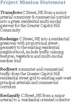
The existing archaic hap-hazard network of residential streets used and/or designated to expedite and accommodate commuter and commercial traffic pits residents against commuters. We can efficiently, effectively and safely convey existing motor-vehicle traffic volumes in, out and around DC without compromising residents’ quality-of-life. It is possible to strike a balance between residents and visitors (workers, tourists, Fed. Gov., national events, etc.) to create and maintain a vibrant city both ‘users’ can enjoy. And realistically, it is a symbiotic relationship, the two user-types need each other to thrive.
So, how do we achieve such a righteous goal? We need to develop and systematically execute a consensus-based master plan with a definitive time-line.
The master plan should include:
1. Prioritize pedestrian and cyclist safety and enjoyment
2. Restore and improve existing parks and open-spaces, tree canopies and vegetative areas
3. Safely connect neighborhoods to public open-spaces, parks, schools and commercial corridors with minimal direct interaction with vehicular roadway traffic
4. Shift regional and city rush-hours vehicular traffic patterns/routes from the neighborhood street grid, and surrounding open-spaces, to existing designated principle arterials and commercial corridors
5. Educate and condition motorists (commuters, tourists, commercial-drivers) to the benefits of using designated routes to either access downtown or regional freeway infrastructure
6. Fund maintenance of existing mass-transit infrastructure and heavily invest in capitol improvement projects that enhance access to our existing mass-transit, walking and cycling systems.
Ward 6 has all the pieces to begin and follow-through with such a transformation...
• Residents' Support - indirect and direct through lifestyle & activism
• Leadership – folks like Council Member Tommy Wells who is a leader in the DC urban movement and DDOT Director Gabe Klein who is reprioritizing DDOT to focus on mass-transit and residents’ desire for pedestrian and cyclist oriented streets and neighborhoods
• Existing Transportation Infrastructure - Anacostia Riverwalk Trail, Stadium/Armory, Eastern, Potomac and Union Station Metrorail Stations, Future H Street/Benning Road Streetcar, bicycle lanes, metro-bus routes, DC/I-295, I-395 and the Anacostia River
• Existing Natural & Planned Outdoor/Open-spaces - Stanton Park, Lincoln Park, Anacostia River and waterfront, Kingman & Heritage Islands, Langston Golf Course, Steward Park, Garfield Park, National Mall, etc.
• Amenities - acces to Barracks Row, Eastern Market, H Street/Benning Road Corridor, Union Station, Pennsylvania Ave Corridor, etc
The key to our success is redirecting commuter and commercial vehicle/motorist cut-through traffic onto existing principle arterials and commercial corridors. Make it less appealing to use the Greater Capitol Hill neighborhood street grid and make it more appealing to use existing east-west principle arterials and commercial corridors.
The below map indicates existing east-west oriented principle and minor arterial roads (in red), which are primarily commercial corridors and interstates, that could carry a majority of the existing volume of commuter and commercial motor-vehicle traffic traversing in and out of downtown and regional traffic traveling to destination beyond city limits. As the map indicates, using these existing roadways, large residential areas could be spared and relieved of the vast majority of the daily cut-through motor-vehicle traffic.

Let's discuss it and move forward together; we can definitely achieve a great balance within a few years! Policy, advocacy, education, design, implementation and maintenance (actually, continual improvements) collectively can create a truly livable, walkable, bikable community for Ward 6.
Thoughts? Ideas? Comments? ...let me know,
Ken G.
cstreetneproject@gmail.com
C Street, NE Project